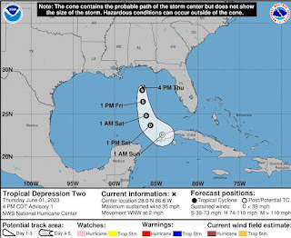
Today is the first day of the 2023 Atlantic Hurricane
Season, and we start off with the formation of a tropical
depression (TD 2) in the Gulf of Mexico. The 4:00
pm EDT forecast for the system expects the system to drift south, away from
the Florida panhandle and become a short-lived tropical storm (TS Arlene).
While this season is forecast to be a just average
season (12 to 17 named storms, of which five to nine are predicted to
become hurricanes, between one and four of those hurricanes could be category 3
or greater), the uncertainties in that forecast are large. But as one commentor
noted (can’t find the link or the name, sorry) the hurricane that hits you is
anything but average.
We have seen a trend in recent years for lingering storms,
dropping a great deal of rain over a relatively smaller area with historic
levels of flooding. So chemical facilities anywhere near the Gulf Coast or
Atlantic Coast need to have plans in place to prepare for the common storm
effects; strong winds, storm surge and prolonged flooding. And those plans need
to be based upon, not the worst that has happened, but on what the new worst is
likely to be. And then add 10%, just to be sure.


No comments:
Post a Comment